
Hi
i have a request in real estate where the customer wants to be able to use some Cartography (example : French geographical departments) to select some geographic region and then add some criteria.
The goal would be to select a type of housing (house, flat) and find the list of availabilties in a region.
Did somebody use such kind of Graphical cartography in OE / RB mobile ?
What could be done using our solutions ?
Regards
Hmmmm..... I don't see why not although I am not sure which bit you are not sure you can do? Are you talking about showing things on Maps? Definitely doable. Are you talking about showing things using location boundaries? Definitely doable (to some degree. I have done it for one of my projects in a rough distance radius for a point manner. Not sure about doing boundaries that are diagonal, etc. Would probably be a way of doing it but would depend on how perfect the solution needs to be (i.e. can you get away with a box that covers the North-Eastern most point to the South-Western most point)). Do you call out to another service to get data (like the actual regional boundaries)? Definitely possible.
Maybe expand out what you would see the issues as being.
TIA
The global goal would be to find some housing at a certain distance
I have a map with my location.
I want to define some circle around me to delimit the max distance i want to consider where i will find some housing.
I found some way using Lat and Long to calculate distance between 2 locations. what i saw on a certain application , is the way to draw this "circle" and use it for the rest of the query.
In fact .... this is more a graphical or User Interface trick because the parameters would be in the end :
- my location (long , lat)
- the distance (max) i want to locate some housing.
The only thing missing is how could i have something to draw with "my finger" on a map on a mobile device....!!!
So, I tried to think about the circular concept of max distance from a point. If it had to be 100% accurate (or at least more circular, you might be able to do that like this (unless someone has a better idea). So if you find all the items that are in the range from the top right corner of the map area (worked out by Lat - wanted distance and lng + wanted distance) to the bottom left point (worked out but Lat + wanted Distance and Lng - wanted distance) (these lat/lng measurements are off the top of my head). This gives the area like this box but you want just the circle in it.
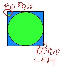
So, if you then test the actual distance from the starting point and see if it is in the range you want, it should weed out the items that are in the "blue" corner areas between the circle and the box.
Is this the issue you are see it tough creating or is it something else?
Note: for my app, it isn't important to be accurate enough for the circular type area and so I just left it with the range from the top Right to the bottom left.
HTH
Laurent,
I used the Google Maps API (from OE Mobile) to perform geolocation and other services. The JavaScript API is documented at developers.google.com/.../reference . It can do things like draw circles around a point, search for places and more.
HTH,
-- peter
Have a look at this excel file , perhaps it will give you some answers
[View:~/cfs-file.ashx/__key/communityserver-discussions-components-files/17/LatLong.zip:550:0]